
Portsmouth coastal visualization survey tackles sea level rise
Town seeks community input
PORTSMOUTH — A new project by the Town of Portsmouth and the Rhode Island School of Design will gather community input on issues of sea level rise and storm vulnerability.
The …
This item is available in full to subscribers.
Please log in to continue |
Register to post eventsIf you'd like to post an event to our calendar, you can create a free account by clicking here. Note that free accounts do not have access to our subscriber-only content. |
Day pass subscribers
Are you a day pass subscriber who needs to log in? Click here to continue.
Portsmouth coastal visualization survey tackles sea level rise
Town seeks community input
PORTSMOUTH — A new project by the Town of Portsmouth and the Rhode Island School of Design will gather community input on issues of sea level rise and storm vulnerability.
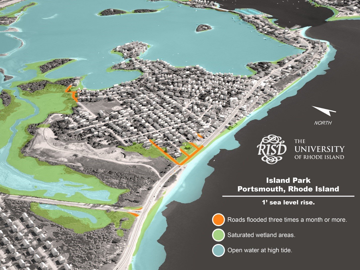
The project centers on a visualization survey that shows the effects of modest levels of sea level rise, such as increased marsh areas and flooded roads in recognizable three-dimensional visualizations of Portsmouth neighborhoods.
The results from this study will be used to help the town better understand citizens’ concerns regarding the near-term impacts of sea level rise and assist researchers to improve visualization practices. Persons over 18 are invited to participate in the survey at www.vissurvey.com.
Tides already flood storm drains on Park Avenue several times a year.
“At extreme high tides, I’ve seen fish and eels swim in the drain across from Flo’s Clam Shack in Island Park,” said Town Planner Gary Crosby. “If that drain is full of water from the ocean, rainwater has no place to go.”
As this kind of flooding becomes more frequent, it will affect road access and the viability of septic systems in this and other areas, he said.
Although the visualizations focus on low-lying areas such as Common Fence Point and Island Park, people from all of Portsmouth are invited to respond, as impacts to these areas affect the entire town.
“We can already see the beginnings of these effects, we need to think about how we’re going to respond,” said Mr. Crosby.
The first step is to better understand residents’ concerns. The town has teamed with the Rhode Island School of Design (RISD) and University of Rhode Island (URI) to create a visualization survey. Three-dimensional visualizations allow people to see likely near-term impacts, such as road flooding and increases in wetland areas in context.
“This is more than a map showing flooding at some distant point in the future,” said RISD researcher Peter Stempel. “We’ve connected the best models from the URI Graduate School of Oceanography with advanced 3-D visualization tools so that we can show more dimensions of what is likely to happen, such as roads that will flood regularly with modest levels of sea level rise. We want to know what people’s real concerns are now — not some distant future point.”
The project is funded by The Rhode Island Program to Stimulate Competitive Research (EPSCoR), a program that funds a wide range of projects focused on the future of Narragansett Bay.
The survey takes less than 10 minutes to complete and is anonymous. This research has been approved by the Brown Institutional Review Board.


