
Will your Bristol home be under water one day?
A workshop Thursday, followed by a walking tour on Oct. 30, will focus on coastal flooding
According to “Historic Coastal Communities and Flood Hazard: A Preliminary Evaluation of Impacts to Historic Properties,” a 2015 report prepared for the Rhode Island Historical …
This item is available in full to subscribers.
Please log in to continue |
Register to post eventsIf you'd like to post an event to our calendar, you can create a free account by clicking here. Note that free accounts do not have access to our subscriber-only content. |
Day pass subscribers
Are you a day pass subscriber who needs to log in? Click here to continue.
Will your Bristol home be under water one day?
A workshop Thursday, followed by a walking tour on Oct. 30, will focus on coastal flooding
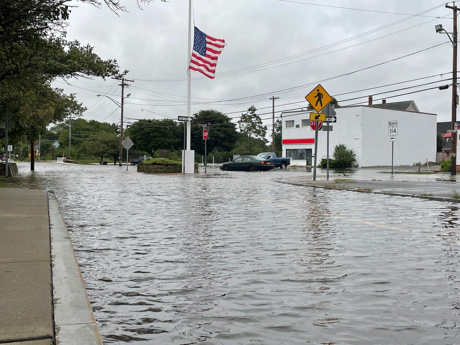
According to “Historic Coastal Communities and Flood Hazard: A Preliminary Evaluation of Impacts to Historic Properties,” a 2015 report prepared for the Rhode Island Historical Preservation and Heritage Commission, Bristol has nearly 200 National Register-listed or eligible properties located within the coastal flood zone, as mapped by the Federal Emergency Management Agency (FEMA). Specifically, the report cites the Thames Street waterfront area, with historic properties including the DeWolf Tavern, the Naval Reserve Armory (now the Maritime Center), and several 18th‐ and 19th‐century residences.
Of course it’s not just historical buildings that will be impacted by sea-level rise and storm surges. Coastal resiliency has long been a concern for town officials, prioritized in the Comprehensive Plan and evidenced by infrastructure plans and projects that consistently seek to improve drainage and minimize flooding risk throughout town. With rising temperatures now producing measurable sea level rise, Rhode Island’s Coastal Resources Management Council and the Army Corps of Engineers are anticipating sea level rise of almost 2 feet by 2030.
Bristol’s Department of Community Development is inviting residents to participate in two events: a Hazard Mitigation planning workshop, Thursday, Oct. 21, at 7 p.m. at the Bristol Maritime Center; and a guided, two-hour Hazard Mitigation Walking Tour, starting at the Bristol Maritime Center, on Saturday, Oct. 30, at 10 a.m. This tour will be led by staff from URI’s Coastal Resource Center and will focus on the potential for coastal flooding along Bristol’s waterfront.
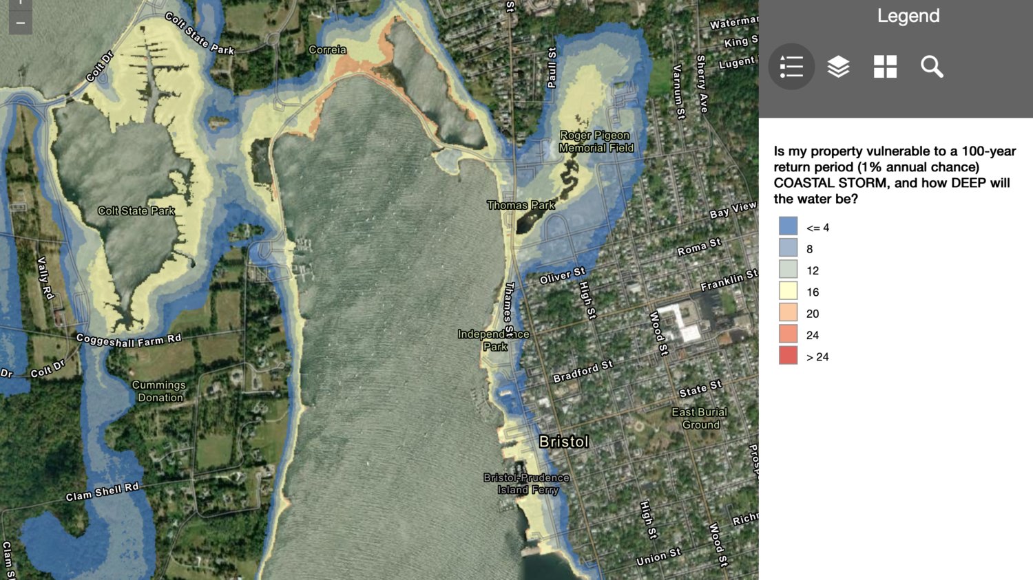
The walking tour will build on the information shared at the Hazard Mitigation planning workshop and offer a visual connection to flood risk from the State of Rhode Island’s online mapper, STORMTOOLS, that illustrates risk from coastal storms and sea level rise. The walk will be accessible and not strenuous. No pre-registration needed, just meet at the Bristol Maritime Center at 127 Thames St.
To explore STORMTOOLS yourself and see your property’s vulnerability to a 100-year storm, visit www.beachsamp.org/stormtools.


