
Bristol bike path engineers decide to go with the flow
New concept favors a network of downtown streets rather than a single preferred route
The plan to extend the East Bay Bike Path through downtown Bristol to the base of the Mt. Hope Bridge has undergone a significant revision. After spending much of 2020 studying possible bike routes …
This item is available in full to subscribers.
Please log in to continue |
Register to post eventsIf you'd like to post an event to our calendar, you can create a free account by clicking here. Note that free accounts do not have access to our subscriber-only content. |
Day pass subscribers
Are you a day pass subscriber who needs to log in? Click here to continue.
Bristol bike path engineers decide to go with the flow
New concept favors a network of downtown streets rather than a single preferred route
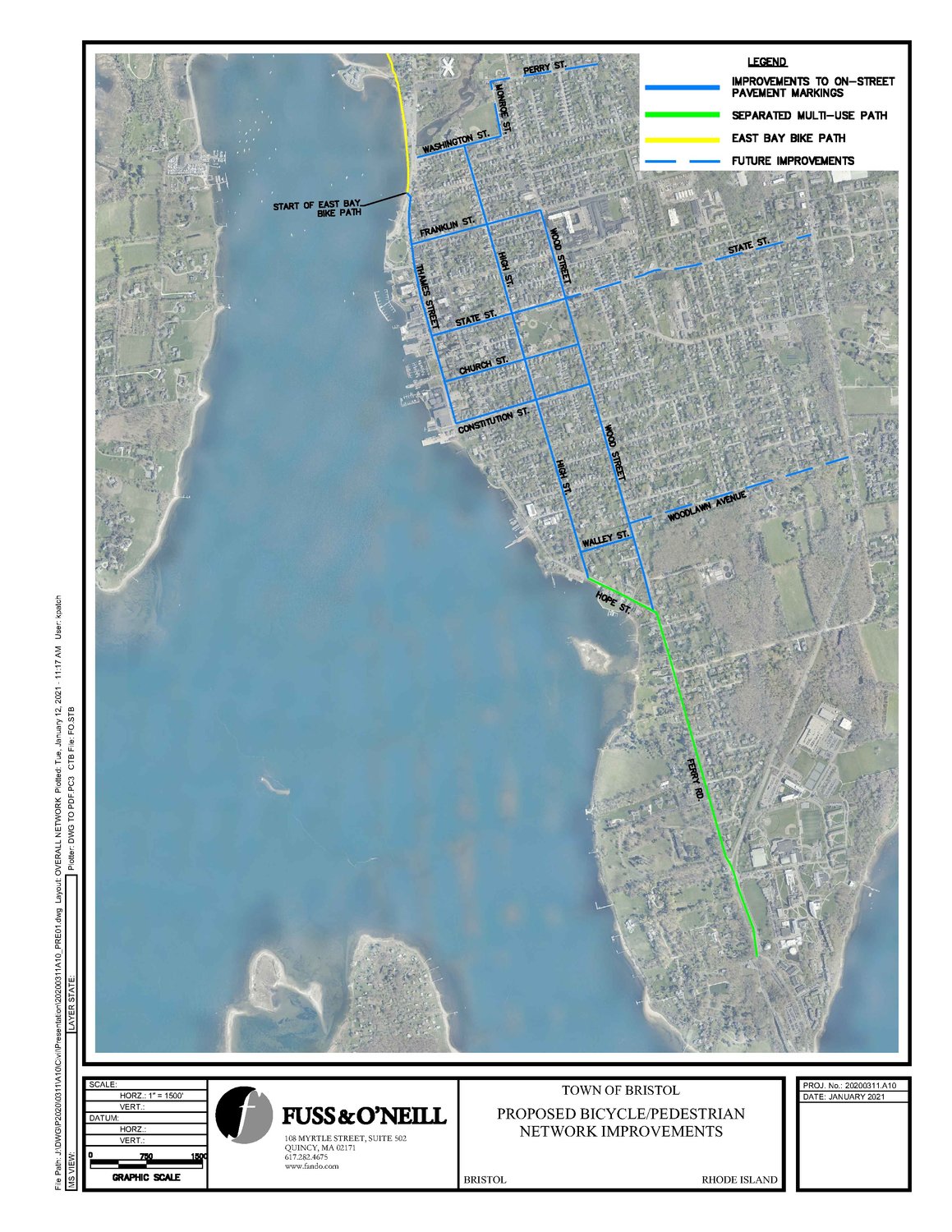
The plan to extend the East Bay Bike Path through downtown Bristol to the base of the Mt. Hope Bridge has undergone a significant revision. After spending much of 2020 studying possible bike routes and honing in on their one preferred north-south path through the downtown district, engineers listened to a dose of feedback from residents, some of them anxious and living directly along the route, and decided it would be best to go with the flow — the flow of bikes, that is.
In November, a design team led by engineer Arnold Robinson of the firm Fuss & O’Neill and Bristol Director of Community Development Diane Williamson presented the bike path plan to the Bristol Town Council. A number of residents, particularly those living along High Street, but also some along Ferry Road, expressed concerns about things like safety, congestion, impacts on parking spaces and more.
In addition, a number of active cyclists spoke at that meeting and other public workshops regarding their own preferred routes downtown, and why.
In the past two months, the engineers and designers listened and developed a new concept: a bike network. Instead of relying on just one clearly defined path through the center of town, they want to improve safety and signage through the grid of streets that lead people north-south.
“Downtown Bristol has a great grid, a beautiful network of streets,” Ms. Williamson said this week. So after hearing from residents and cyclists, “we kind of zoomed back out in our thinking and gave thought to a larger network of routes.”
The result is this proposed route, from north to south:
• It would begin where the East Bay Bike Path currently ends, on Thames Street near Independence Park. This first leg would be a shared roadway along Thames, where cars and bikes both have rights.
• When leaving Thames Street, the route transforms into a network. Cyclists can choose whatever streets they prefer — Franklin, State, Church, Constitution, Union, High, Walley, Wood — to travel further south through the downtown district.
• The preferred location for crossing Hope Street will still be in front of the Lobster Pot restaurant, at High Street, with an activated yellow caution light and a robustly marked crosswalk.
• From there, the route transitions into a more traditional bike path, with a dedicated lane along the south and west sides of Hope Street and Ferry Road, all the way to the Mt. Hope Bridge and the entrance to Roger Williams University.
That central network of downtown streets is the newest aspect of the plan.
“Especially in the downtown neighborhood, there won’t be a specific, dedicated route,” Ms. Williamson said. “There are already a lot of people who bike downtown, so we’re not really introducing new uses into an area where they don’t exist now.”
What they would do is introduce better streets markings, to serve two purposes. The first is to make it clear cyclists have rights to use roads like High Street and others in the downtown grid. The second is to make it clear that everyone needs to obey traffic laws at intersections and crossings — including cyclists.
Ms. Williamson is also quick to add — for the umpteenth time — they are not proposing the removal of any parking spaces along the route.
Workshops begin next week
After the Bristol Town Council reviewed the initial plan back in November, it asked the design team to spend more time reaching out to residents along the route. That effort begins in earnest next week.
There will be four public workshops, with a different focus each night:
• Monday, Jan. 25: Thames Street;
• Tuesday, Jan. 26: Ferry Road and a small section of Hope Street;
• Thursday, Jan. 28: Wood, Walley, Franklin and State streets
• Wednesday, Feb. 3: High, Constitution, Church and Washington streets.
All the workshops will be held on Zoom, with links available on the town’s website. To find the Zoom links, go to: bristolri.gov/category/community-development/.
The town also mailed out approximately 800 notices and invitations to property owners along the entire north-south route, inviting them to review the plan and share feedback.


